Here’s a roundup of what’s changed since June. As always it’s been a busy period of development which we’ve matched with a focus on maintenance and bugfixes. Our backlog of feature and change requests stands at 28 for the UI and 23 for the API with all priority issues resolved.
The deck is now clear for a dynamic network planning feature which will be integrated in December.
UI changes, June to November
With 19 new features/improvements and 69 bugfixes in this period, the user interface has matured considerably due in large part to user feedback from the community. We’ve said no to a few feature requests also which is necessary to keep the interface technology agnostic and easy to use. That doesn’t mean we can’t support complexity or special waveforms directly in the API.
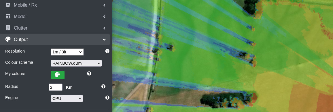
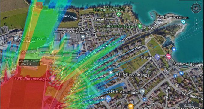
- Radius increased to 400km for aircraft (3.0)
- GPU engine integrated with best server and CSV analysis tools (3.0)
- New 300m resolution for airborne broadcasting (3.0)
- Received Signal Received Power (RSRP) option added to measured units (3.1)
- Account information dialog (3.2)
- GPU Best Site Analysis (3.2)
- Custom WMS and WMTS map sources (3.4)
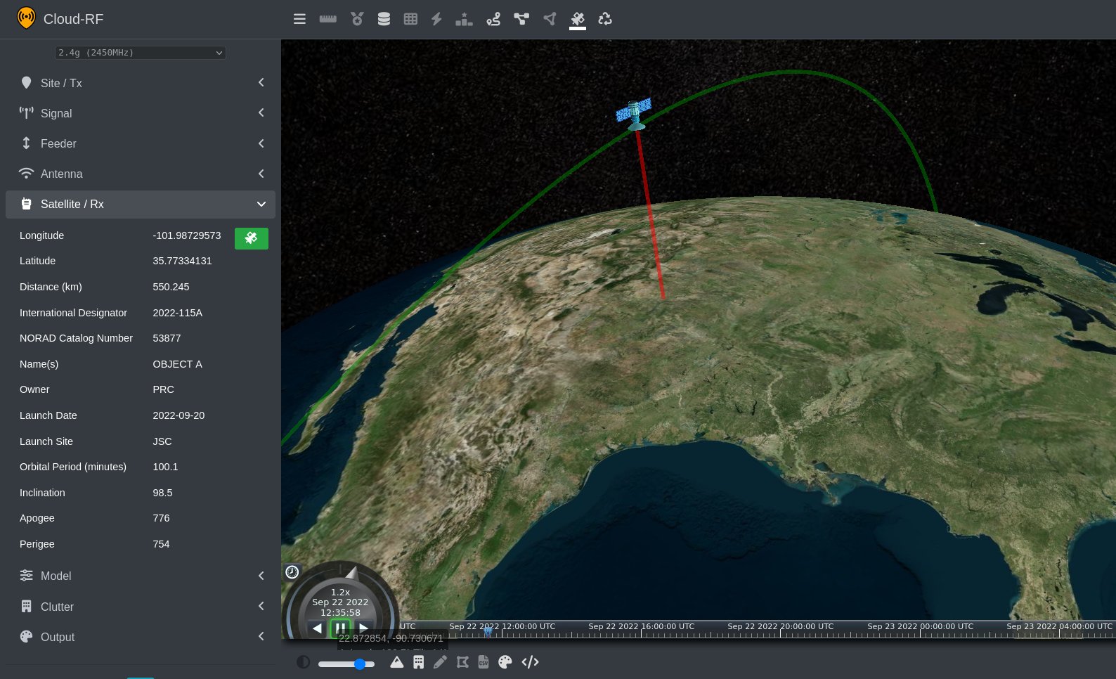
- Satellite database updated (3.4.2)
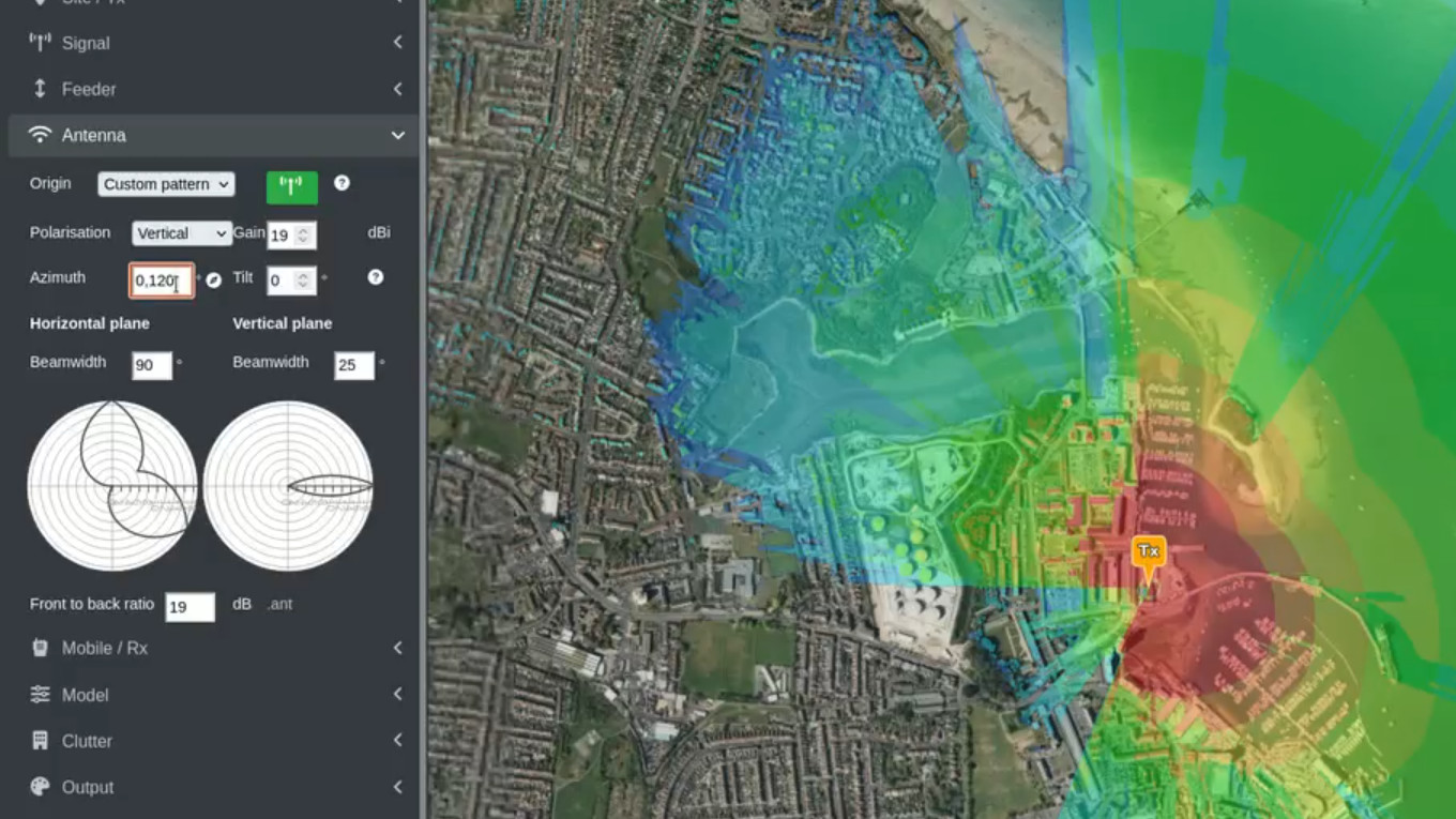
- Multi azimuth antenna patterns (3.5)
- Route, multipoint and path path tools updated for all possible measurement units (3.5.1)
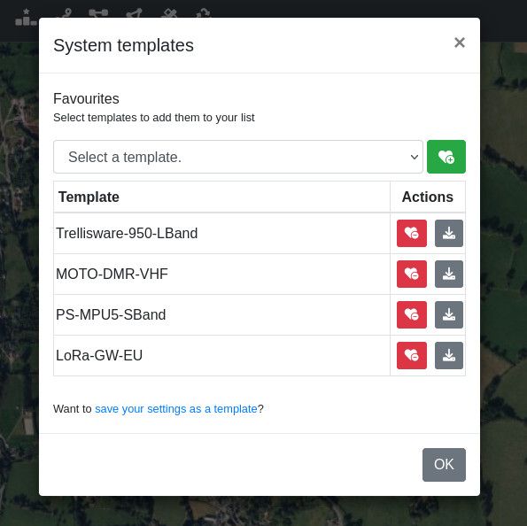
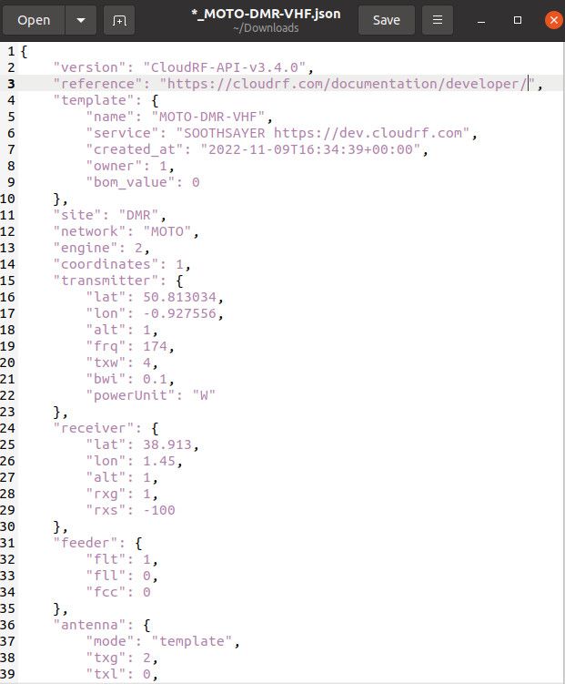
- JSON templates system (3.6)
The long surviving Google Earth interface lives on and has been given a fresh wind thanks to code compatibility libraries which mean we no longer have to worry about breaking it with new Javascript. Long live Google Earth!
UI Changelog
## Version 3.6.1 (2022-11-28)

- Fix: Layer from archive would not load when clicking on the layer name or selecting "Add tower(s) only to map" button.
- Fix: Processing modal window getting stuck when using the Interference or Super Layer tools.
- Fix: Display the power of items loaded from the archive in the selcted power unit.
- Fix: Dynamically move navigator controls down to make space for imagery layer list.
- Fix: Prevent crash when disabling path profile analysis before calculation completes.
- Fix: Refreshes displayed clutter after deleting all clutter using the clutter manager.
- Fix: Selecting a template in the Google Earth interface crashes.
- Fix: MANET nodes sometimes clipped by the terrain resulting in partially hidden markers.
- Fix: Best site analysis tool sometimes goes into "zombie" state under bad network conditions.

## Version 3.6 (2022-11-10)

- Feature: Templates functionality makes use of the new API endpoints and JSON files.
- Feature: Added button to download the JSON template for both custom and system templates.
- Feature: Added modal to add/remove favourite system templates.
- Feature: Dropdown select of templates indicates if the template is a system or custom template by prepending with either "System" or "Custom" respectively.
- Fix: Styling issues on custom template save/delete modal.
- Fix: Reorganised "My Account" modal as was becoming cluttered. Logout button moved to top and managers split into a single row. API usage moved to the bottom.
- Fix: Some API errors which are returned as an array of values would not be parsed as an array, instead the error displayed would be a generic "Request failed." message which wasn't indicative of the error.
- Fix: Don't fire a GPU request when loading a GPU template.
- Fix: Adjusting the `rxs` field manually would not update the receiver sensitivity slider.

## Version 3.5.1 (2022-10-31)

- Feature: Route, Multipoint and Path tools able to display SNR, dBuV and RSRP units as well as dBm.

## Version 3.5.0 (2022-10-18)

- Feature: Multi-azimuth antenna support by sending a comma-separated list of values, for example, `0,120,240`.

## Version 3.4.2 (2022-09-21)

- Update: Satellite database updated to 2022-09-22.
- Feature: Fly to PPA when loading from the archive.
- Fix: Custom pattern vertical beamwidth not visible in the Google Earth interface.
- Fix: Profile drop down not populated and opening the clutter manager in the Google Earth interface.
- Fix: Sensitivity is loaded when selecting a template.
- Fix: Map attribution interfered with satellite timeline controls.
- Fix: Loading PPA from archive and then hovering over chart would cause a crash.

## Version 3.4.1 (2022-09-14)

- Fix: Template saves coax type.
- Fix: Problem toggling the azimuth mode in the Google Earth interface.
- Fix: Problem loading a template in the Google Earth interface.
- Fix: Switching between templates with engine set to GPU and CPU runs area calculation with incorrect engine.
- Fix: Saving a custom map URL cuts off part of URL after an "&".
- Fix: Suspends error logging when library blocked by client.
- Fix: Handle missing preferences.

## Version 3.4.0 (2022-08-31)

- Feature: Custom WMS and WMTS URLs for imagery layers.
- Feature: Attribution text lists API providers.
- Fix: Pruned dead and unsuitable map sources, such as "Blue Marble".
- Fix: Problems with editing coordinates.
- Fix: Antenna patterns not loading properly in some browsers.

## Version 3.3.0 (2022-08-23)

- Feature: Sets free space model with diffraction off and shows warning for best site analysis.
- Feature: Select last network when opening archive to match the last row.
- Feature: Make clutter go to ground.
- Fix: Improved area calculation error handling.
- Fix: Selecting a network in archive drop down when some items have no network would cause a crash.
- Fix: Legacy colour key images not displayed.
- Fix: Super layer KMZ quick-download button fixed for "Merge network"

## Version 3.2.0 (2022-08-15)

- Feature: Account Information dialog.
- Feature: GPU Best Site Analysis.
- Fix: Updates to colour schemas to match recent changes to colour schema API.
- Fix: Buildings layer cannot be removed.
- Fix: Receiver sensitivity icons missing.
- Fix: Creating a clutter profile does not refresh the list.
- Fix: RSRP breaks MANET.
- Fix: Opacity slider doesn't work.
- Fix: MANET reload by name click and best server for imperial units mi/f.
- Fix: Crash clicking layer checkbox while layer is loading.
- Fix: Default RSRP schema not always selected.
- Fix: Interference tool is trying to map colours to colour key.
- Fix: Crash saving clutter polylines with less than 2 coordinates or polygons with less than 3 coordinates imported from kml.
- Fix: Crash downloading MANET metrics report when node evauation failed.
- Fix: Power unit in MANET node details dialog displayed as undefined.
- Fix: Node percentanges on MANET metrics report sometimes NAN.
- Fix: Points CSV validation no longer works.
- Fix: Entity already exist in collection when disabling MANET.
- Fix: Crash adjusting bsa sliders when result loading failed.
- Fix: BSA images not recoloured on colour schema changed.
- Fix: Custom antenna polar plot not displayed in Google Earth.

## Version 3.1.0 (2022-07-18)

- Feature: Added Received Signal Received Power (RSRP) as an option to the "Measured Units" dropdown.
- Fix: Deleting multiple selected networks will now give the name of the networks rather than the ID.
- Fix: Selecting a PSK/QAM modulation will only show supported PSK/QAM bit-error-rate values, and likewise when selecting a LoRa modulation.
- Fix: Deleting a network from the archive now gives a better modal message rather than a browser `alert()` window.
- Fix: Occasional crash when computing azimuth and tilt for the mouse tootltip for satellite mode when the position has not been computed yet.
- Fix: Can't find variable `Map` in Google Earth interface.
- Fix: Crash in Google Earth when logging error information.
- Fix: Prevents crash in Google Earth interface when changing clutter profiles.
- Fix: Formatting issue in Google Earth.
- Fix: Helper dialog describing channel noise adjustment when changing bandwidth
- Fix: Tx Height AGL and RF Power textboxes extending over unit drop downs.
- Fix: Crash in Google Earth interface when you change properties that would update the map location when in web UI.

## Version 3.0.1 (2022-07-06)

- Feature: Added support for 180m and 300m resolutions.
- Fix: GPU is populated in dropdown of processing engines when GPU isn't available.

## Version 3.0 (2022-07-04)

- Feature: Radius limit now 400km.
- Feature: GPU processing no longer handled through WebSocket, instead goes through the same API as CPU processing for simplicity. Removed button to close GPU processing engine, instead you now just switch back over to CPU mode from the dropdown in the "Output" menu.
- Feature: Integration of GPU engine with other tools including best server and CSV import.
- Fix: Colour schema list gets populated with some empty values when using GPU mode.
- Fix: Prevents failure on area calculation due to invalid input from logging an error.
- Fix: Interference dialog not always populating networks.
- Fix: Duplicate entry for gpu in the engine drop down.
- Fix: Some antenna patterns were not being saved in templates.
API changes, v3.0 June to 3.6 November
With 30 improvements and features and 28 bugfixes, the API has largely remained the same from a developer’s perspective but it now has more consistency between the CPU and GPU engines, more choice with defining antenna azimuths and more useful error messages to help developer’s make better choices and save time.
Under the hood, the ATAK interface has had a major refactor to support customer’s official TAK Server’s with our infamous chatbot. A new chatbot management interface has been especially created which can validate certificate chains using OpenSSL to warn of issue before you get to them eg. “This certificate is invalid” or “This key is incorrect” or “Cannot ping your TAK server”.
GPU integration
The new GPU engine has received several updates throughout this period to add models, gains, antenna patterns, multi-azimuth patterns and output styling inline with the CPU engine, SLEIPNIR.
In September, the powerful Best Site Analysis capability was integrated with ATAK. When the SOOTHSAYER bot is connected to the TAK server, any polygon sent to it will generate a BSA layer.
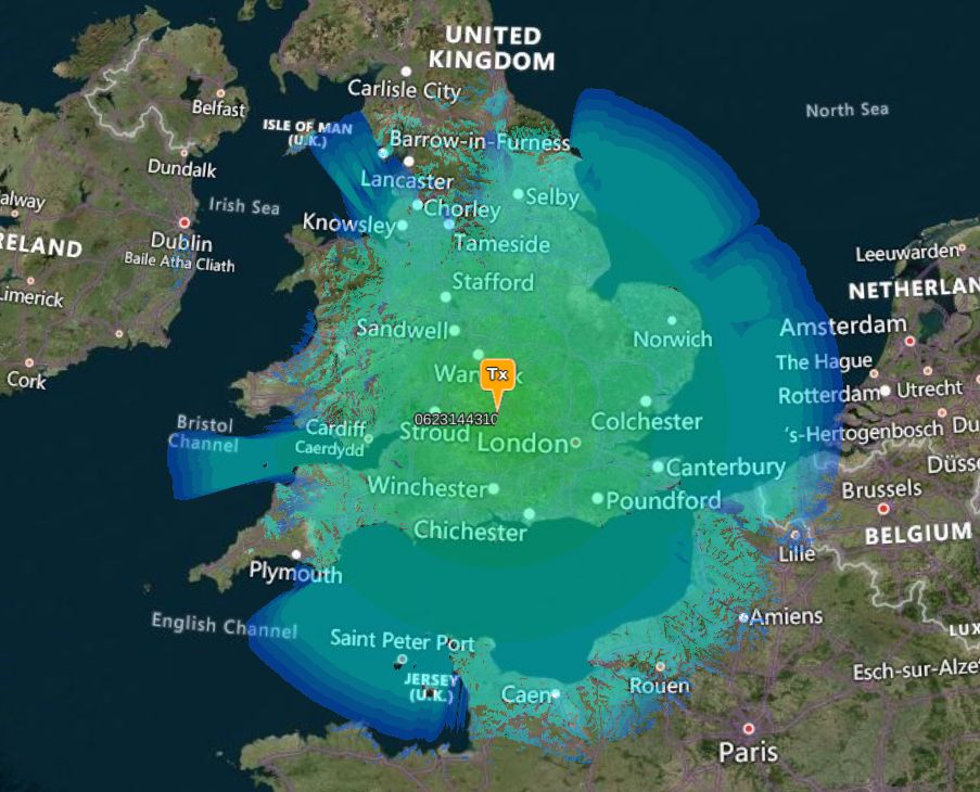
Due to demand, the maximum radius for the GPU engine was increased to 150km to support broadcasting. During GPU testing we were generating 100 mega pixel (100,000,000 points) heatmaps in a few seconds which is too large for a client. We are working on a scalable solution to visualise images of this resolution as an image pyramid.
SLEIPNIR mods
The SLEIPNIR CPU engine is now at version 1.6.1 and has conditional smoothing of coarse DTM, knife edge diffraction from clutter (note we already do this for surface models) and slightly (3dB) more optimistic diffraction following feedback from a mountain rescue team.
Received Signal Received Power (RSRP) is not native to the engine instead of the API and the reliability variable can now be used for non-ITM models to provide a 10dB tuning margin where 50% is 0dB and 99% is 9.9dB path loss.
The maximum radius has been increased to 400km for airborne platforms. To support the larger radius, we’re also offering a new low resolution of 300m.
API management
The V1 “URL” API will be retired at the end of this year. Users who have integrated with this API should migrate to the new JSON API as soon as possible. The new JSON API has been powering the web interface for almost two years.
Reference: https://cloudrf.com/documentation/developer/
API Changelog
## Version 3.6.0 (2022-11-25)

- Deprecation: Added deprecation message to `v1` API endpoints. The `area` and `path` will be removed on the 31st December 2022. Please migrate any scripts to the new JSON API and see https://cloudrf.com/documentation/developer/
- Fix: Chatbot welcome-storm with other chatbots.
- Fix: Obsolete paths on terrain coverage map and HTML PPA response.
- Fix: Improvements to automation testing.
- Fix: Sending malformed JSON to a `v2` API endpoint now returns a useful error message.
- Fix: Deprecated `v1` API endpoints were incorrectly counting API credits.
- Fix: Power value of 1mW for GPU fails.

## Version 3.5.0 (2022-11-10)

- Feature: Moved from database-driven to JSON-driven templates with new API endpoints to manage custom templates.
- Feature: System templates can be retrieved and saved as a favourite using new endpoints.
- Fix: Race condition on GPU processing files as its so damned fast.
- Fix: Public shares for GPU layers needed reprojecting to EPSG 3857.

## Version 3.4.0 (2022-10-18)

- Feature: Gain support for GPU engine.
- Feature: Antenna support with azimuth and tilt for GPU engine.
- Feature: Multi-azimuth support for antennas by sending a comma-separated list of values in the `antenna.azi` value, for example, `0,120,240`.
- Fix: Path tool on TAK successfully returning only about 50% of the time.
- Fix: Area requests to `v1` API returning colour key data in improperly formed string values.
- Fix: `clutter` command on TAK chatbot working again.
- Fix: Resolved issue with custom colour schemas and low resolution screens.
- Fix: Sanity check ADF files.
- Mod: Default clutter templates adjusted. Urban height reduced to no more than 2m.
- Mod: GPU engine max radius capped at 10km (CPU max = 400km).

## Version 3.3.0 (2022-09-22)

- Feature: Support for TAK server 4.7 through Chatbot and ATAK.
- Feature: Extended response information when executing `id` to Chatbot through ATAK.
- Feature: Support for GPU BSA on Chatbot with the multipoint tool through ATAK.
- Feature: Added new chatbot manager to spin up chatbots on demand which interact between TAK servers and API.
- Feature: Extended preferences functionality to allow for custom imagery.
- Feature: Delete all clutter button added to clutter form.
- Fix: Processing engine saved in templates.
- Fix: Commercial restrictions messages now return HTTP 403 (Forbidden) rather than HTTP 400 (Bad Request).

## Version 3.2.0 (2022-08-15)

- Feature: System colour schemas no longer able to be deleted by a user so that users will always have a list of schemas to choose from.
- Feature: Height ceiling increased to 120km over 60km.
- Feature: When using Greyscale GIS colour schema no longer returns validation error for mixing outputs and schema.
- Feature: Improvements to the PPA KMZ export with fresnel support and new icons for transmitter, receiver and obstructions.
- Fix: Improvements to the functionality of the colour schema generator.
- Fix: Creating a BER colour schema fails with a HTTP 500.
- Fix: Update to `preferences` stripping out underscores from colour schemas.
- Fix: Google Earth layer no longer allows to manage colour schemas. Added notice with workaround instructions.

## Version 3.1.0 (2022-07-18)

- Feature: Improvements to `preferences` to extend to additional values and give information about a users plan.
- Feature: Improvements to precendence of preferences, where in some cases a previous request values will be taken over a users preferences.
- Feature: Colour palette bucket limit increased to 75.
- Feature: Return request to `preferences` as a correct JSON response.
- Feature: Users with a private server will now be indicated when they make a request to `preferences`.
- Feature: Colour pallette creator extended to support Bit-Error-Rate measured units.
- Feature: Bit-Error-Rate modulation extended from 10e-6 to 10e-8.
- Feature: Allowed support for Received Signal Received Power (RSRP) measured units with an `out` value of `6`.
- Feature: Added default RSRP colour key.
- Feature: SLEIPNIR 1.6.1 calculates and returns (LTE) RSRP if selected
- Feature: SLEIPNIR 1.6.1 uses reliability for non-ITM models with a 10dB range. 50% = +0dB, 99% = +9.9dB
- Fix: Successful deletion of networks in the archive are returned with a success `message` rather than `error`.
- Fix: Correct names of plans when making a request to `preferences`.
- Fix: BER colour palette in JSON response was missing unit.
- Fix: Improvements to the default `PATHLOSS.dB` colour key.
- Fix: Hata model high-plateau issue resolved in SLEIPNIR 1.6.1

## Version 3.0.1 (2022-07-06)

- Feature: Resolution supported up to 300m.

## Version 3.0 (2022-07-04)

- Feature: Improvements to GPU processing with the use of remote processing nodes.
- Feature: GPU produced images are now styled in the API based on the specified colour schema.
- Feature: Extended `data` API to retrieve a tile based only on tile name.
- Fix: Logic issue with users mixing credits and plan was incorrectly refusing service to users with expired plans, but spare credits.
- Fix: Custom clutter profiles are created with the list of 101 to 199 clutter codes.
- Fix: Obtaining height data from OpenStreetMaps would sometimes fail.
- Fix: KMZ download failing on equator
That’s all folks.
