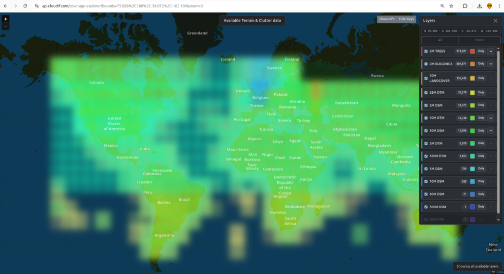
We have terrabytes of global data including LiDAR, DTM, Tree canopy data and 3D buildings which we are constantly updating. You can zoom into your area of interest to investigate what we have and also get the source and year for the data.
Data providers
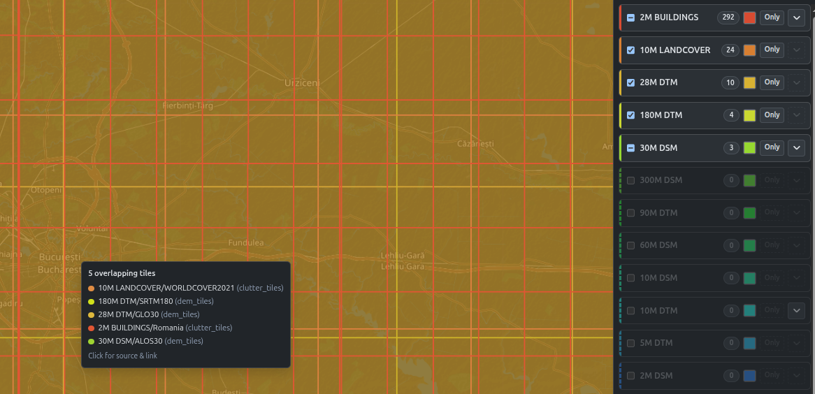
We convert and host terrabytes of public data from a wide variety of GIS sources down to 1m resolution. For more details such as data URLs and accessed year use the interactive coverage map.
| Supplier | License |
| © Environment Agency | Open Government Licence |
| © GDI-Th | Datenlizenz Deutschland – Namensnennung – Version 2.0 |
| © GeoBasis-DE/LVermGeo SH/CC BY 4.0 | CC BY 4.0 |
| © GeoBasis-DE/M-V 2025 | CC BY 4.0 |
| ©GeoBasis-DE / LVermGeoRP 2025 | DL-DE->BY-2.0 |
| Administration du cadastre et de la topographie Luxembourg | CC0 |
| agentschap Digitaal Vlaanderen | Model license for free reuse |
| AHN.nl | CC BY 4.0 |
| Amt für Landesplanung und Kartografie, Autonome Provinz Bozen | Creative Commons CCZero |
| Bayerische Vermessungsverwaltung | CC BY 4.0 |
| BEV – Bundesamt für Eich- und Vermessungswesen | CC-BY-4.0 |
| burgenland.at. Land Burgenland | Creative Commons Namensnennung 4.0 International (CC BY 4.0) |
| CC-BY 4.0 scne.es 2025 | CC BY 4.0 |
| cuzk.gov.cz. Land Survey Office | CC-BY 4.0 |
| Dati estratti dal Modello Digitale del Terreno (DTM) della Regione Autonoma Valle d’Aosta | CC BY 4.0 |
| Direção-Geral do Território | CC BY 4.0 |
| DLR e.V. 2010-2014, Airbus Defence and Space GmbH 2014-2018, provided under COPERNICUS by the European Union and ESA. All rights reserved. Accessed via OpenTopography and AWS Open Data. | COPERNICUS full, free and open license |
| Elevation data 2021-2024, Republic of Estonia Land and Spatial Development Board | Republic of Estonia Land and Spatial Development Board opendata licence 2025 |
| ESA | Public |
| European Space Agency | © DLR e.V. 2010-2014 and © Airbus Defence and Space GmbH 2014-2018 provided under COPERNICUS by the European Union and ESA; all rights reserved. |
| Federal Office of Topography swisstopo | Open Government Data |
| Freie und Hansestadt Hamburg, Landesbetrieb Geoinformation und Vermessung (LGV) | Datenlizenz Deutschland – Namensnennung – Version 2.0 |
| GeoBasis DE/LVGL-SL 2025 | Datenlizenz Deutschland – Namensnennung – Version 2.0 |
| GeoBasis-DE / LGB | Datenlizenz Deutschland – Namensnennung – Version 2.0 |
| geoland.at, Land Kärnten. | CC-BY-4.0: Land Kärnten – data.gv.at |
| Geoscience Australia | CC BY 4.0 |
| GeoSN, dl-de/by-2-0 | Datenlizenz Deutschland – Namensnennung – Version 2.0 |
| Head Office of Geodesy and Cartography (GUGiK), National Geodetic and Cartographic Resource (PZGiK), Poland | Open Government Data (Art. 40a. geod. i kartogr.) |
| Hessisches Ministerium für Umwelt, Klimaschutz, Landwirtschaft und Verbraucherschutz | Datenlizenz Deutschland – Zero – Version 2.0 |
| Institut national de l’information géographique et forestière IGN | Licence Ouverte / Open Licence version 2.0 |
| Instituto Geográfico Portugês | CC BY 4.0 |
| Istituto Nazionale di Geofisica e Vulcanologia (INGV) | Creative Commons Namensnennung 4.0 International (CC BY 4.0) |
| JAXA | Public |
| Kartverket | CC BY 4.0 |
| Klimadatastyrelsen Danmark | CC BY 4.0 |
| ktn.gv.at. Land Kärnten | CC-BY-4.0: Land Kärnten – data.gv.at |
| land-oberoesterreich.gv.at. Land Oberösterreich | Creative Commons Namensnennung 4.0 International (CC BY 4.0) |
| Landesamt für Vermessung und Geoinformation Sachsen-Anhalt (LVermGeo) | Datenlizenz Deutschland – Namensnennung – Version 2.0 |
| Landesamt GeoInformation Bremen | CC-BY-4.0 |
| Landesamtes für Geoinformation und Landesvermessung Niedersachsen (LGLN) | CC BY 4.0 |
| Lantmäteriet | CC0 |
| Latvijas Ģeotelpiskās informācijas aģentūra | Creative Commons Attribution 4.0 |
| LGL, www.lgl-bw.de, dl-de/by-2-0 | Datenlizenz Deutschland – Namensnennung – Version 2.0 |
| MDT02-cob2 2015-2021 CC-BY 4.0 scne.es | CC BY 4.0 |
| Meta | DINOv3 License |
| Microsoft | CLDA Permissive 2.0 |
| Ministerium des Innern des Landes Nordrhein-Westfalen | Datenlizenz Deutschland – Zero – Version 2.0 |
| NASA JPL | Public |
| National Land Survey of Finland 2025. Downloaded via GeoCubes. | Attribution 4.0 International (CC BY 4.0) |
| Natural Resources Canada | Open Government Licence – Canada |
| Natural Science Institute of Iceland | CC BY 4.0 |
| Norwegian Polar Institute | CC BY 4.0 |
| producer | license |
| Provincia Autonoma di Trento – Ufficio Sistemi Informativi – Servizio autorizzazioni e valutazioni ambientali | CC BY 2.5 |
| Regione Autonoma della Sardegna | CC-BY 4.0 |
| Regione Lombardia | CC BY 4.0 |
| Regione Piemonte – A1613B – Sistema informativo territoriale e ambientale | CC BY 4.0 |
| Regione Siciliana – Assessorato del Territorio e dell’Ambiente – Area 2 Interdipartimentale – Nodo Regionale S.I.T.R | CC-BY 4.0 |
| salzburg.gv.at. Land Salzburg | Creative Commons Namensnennung 4.0 International (CC BY 4.0) |
| Scottish Government | Open Government Licence |
| Senatsverwaltung für Stadtentwicklung, Bauen und Wohnen Berlin | Datenlizenz Deutschland – Zero – Version 2.0 |
| Service public de Wallonie (SPW) | CC-BY 4.0 |
| Slovenian Environment Agency (ARSO) | Creative Commons Attribution 4.0 |
| The Faroese Environment Agency, Umhvørvisstovan | Open Government Data |
| the National Land Authority (NLA), Water and Sanitation Corporation (WASAC) Ltd., Rwanda through UNDP, EMD, and windPRO | Creative Commons Namensnennung 4.0 International (CC BY 4.0) |
| Toitū Te Whenua Land Information New Zealand | CC BY 4.0 |
| U.S. Geological Survey | Public Domain (U.S. Government Work) |
| ÚGKK SR | CC BY Creative Commons Attribution („uvedenie autora“) 4.0 |
| Welsh Government and NRW | Open Government License |
| www.geoportal.gov.ro | Romanian Open Government License v1.0 (OGL-ROU-1.0) |
| Τμήμα Κτηματολογίου και Χωρομετρίας | CC BY 4.0 |
| 国土交通省国土地理院 | 国土地理院コンテンツ利用規約/測量法に基づく国土地理院長承認(使用)R 7JHs 542 |
