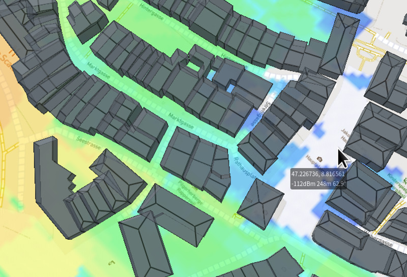
Visualising the physical environment has never been easier, thanks to powerful end-user devices running mapping software with hardware acceleration. The latest step in the evolution of mapping is the shift from “2.5D” representations to full three-dimensional terrain and models. The OGC standard for this novel format is called 3D Tiles. … Read more: 3D Tiles at the edge
Overview The Tough Stump Rodeo is an outdoor edge technology demonstration set in rural Montana.Selected companies collaborate to integrate their capabilities with the ATAK common-operating-picture to complete communications challenges. CloudRF participated for the first time as a key enabler on the most challenging lane, the sub-terranean, which required participants to… Read more: Tough Stump Rodeo 2026
Modelling Radar and Wireless interference in the 5GHz range Background In the early morning of the 4th of July 2025, the Australian warship HMAS Canberra sailed down the west coast of the North Island of New Zealand. It had its navigation radar on, surveying the sea for obstacles. At the… Read more: How a passing Warship took out a town’s Internet
The rapid growth of Counter Unmanned Aerial Systems (C-UAS) across government, public, and commercial sectors has increased the need for accurate modelling to improve sensor siting and effectiveness. This blog explores how Counter- (C-UAS) and RADAR systems can be modelled efficiently within CloudRF to optimise siting and improve their effectiveness. The challenge The methodology for operating sensors varies depending on… Read more: Optimising drone detection with RF simulation
The first feature release of 2026 brings new MANET APIs with receiver antenna patterns, a major container refactor, offline 3D terrain, high accuracy tree canopy data and simpler licensing. Multi link API This API is designed for mesh and MANET networks and has already replaced the points API for the… Read more: SOOTHSAYER 1.11 released
Author: Cameron Mickell A common question for novice planners is which RF propagation model is best for my technology? We have many different users employing diverse technologies, time constraints and accuracy requirements, so it is not always a quick answer but knowing about the key types of models and where… Read more: Choosing an RF Propagation Model
Summary We conducted a field test in the mountains with SOOTHSAYER focused on automation and endurance. The test generated quality data and revealed altitude issues with our plugin we have since fixed. We conducted a field test in the mountains with SOOTHSAYER focused on automation and endurance. The test generated… Read more: Live network mapping endurance test
Background Radio Direction Finding (DF) is the art of determining the location of an emitter and is used in search and rescue, coastal surveillance, law enforcement and defence. There are different techniques using power and phase but the output for a single sensor is normally a Line of Bearing (LoB)… Read more: Enhancing Radio Direction Finding with RF simulation
To Survey or Simulate Whether its survey drones, drive test vehicles or a police analyst with a backpack full of phones, the problem is the same: RF propagation surveys are very resource intensive. They’re more accurate than a simulation, but not more efficient. Survey data is typically a GPS log… Read more: Fast simulation calibration with Machine Learning
Our latest feature release for our self-hosted server is out now and majors on offline data and security hardening. It’s a release aimed at administrators with six months of CloudRF fixes and features including the noise layer. Offline data packs Since we released pre-built images with 1.9, the setup effort… Read more: SOOTHSAYER 1.10 released
Highlights Background Three years ago we developed a “live” simulation capability using location-aware MANET radios which we described as dynamic radio planning which fused real and planned radio positions. This feature required a third party hardware API with restrictive terms, common in commercial radio, so it exists as a video… Read more: Live RF coverage mapping with ATAK
Summary We have optimised how our engines model attenuation and diffraction to improve accuracy and performance within forests (and buildings). Highlights Evolution of attenuation and/or diffraction When a radio signal hits an obstacle such as a building, it attenuates through the obstacle and diffracts over the obstacle. Depending on the… Read more: Improving accuracy in the trees
Noise is the single biggest factor in determining the quality of a communications link. It’s also the reason why there is low confidence in the accuracy of (RF) simulation in complex environments as it’s rarely done well, if at all. Budgeting for noise is critical to achieve desired signal levels.… Read more: Mapping Noise
We’ve published a series of video tutorials for HF novices to bring to life HF theory around the topics of Frequency selection, Antenna fundamentals and forecasting. HF communications is very different to terrestrial communications and given the right frequency, time of day, and antenna, you can achieve long range links… Read more: The art of HF
Our latest feature release improves offline setup and adds support for HF Skywave, interference analysis and indoor simulation. Offline by default With pre-built images, offline install is now enabled by default. This was developed to both speed up the install, ensure all dependencies are present and correct and automatically assign… Read more: SOOTHSAYER™ 1.9 released
Developments in containerised software and portable GPU hardware have enabled RF simulation at the network edge. Field testing has proven this powerful capability can serve multiple clients from a small battery for a sustained period of time. Key findings Test setup An Nvidia Jetson Orin nano 8GB processor was paired… Read more: RF planning at the Edge
Simulating indoor radio coverage for first responders has been made simpler thanks to a new capability called Phase Tracing. The novel design was influenced by the 2017 Grenfell Tower inferno, where radio communication in concrete stairwells was highlighted as a major problem. The Grenfell inquiry highlighted radio and training issues… Read more: Phase Tracing interface
Interference is one of the single biggest issues in radio which limits the potential of a system or network. There are different types of interference but the problem of interference visualisation is common to all. With simulation software you can model your system, and an interfering system, but understanding the… Read more: Interference analysis
HF Ionospheric propagation, known as Skywave, has been added to the CloudRF API. While Satcom offers clear advantages in terms of speed, bandwidth, and the ability to provide real-time, high-quality data transmission, HF remains a crucial alternative where cost, independence from satellites, portability, power efficiency, and resiliency are important. Wide… Read more: HF Skywave
Our latest feature release adds new APIs and retires the virtual machine for a container-first solution compatible with more host systems which enables GPU sharing and greater control over both code and user data. 3D API A new full 3D API and GPU engine designed for urban simulations with multipath,… Read more: SOOTHSAYER 1.8 released
We use cookies on our website to remember your preferences and repeat visits. By clicking “Accept”, you consent to the use of cookies.
This website uses cookies to improve your experience while you navigate through the website. Out of these, the cookies that are categorized as necessary are stored on your browser as they are essential for the working of basic functionalities of the website. We also use third-party cookies that help us analyze and understand how you use this website. These cookies will be stored in your browser only with your consent. You also have the option to opt-out of these cookies. But opting out of some of these cookies may affect your browsing experience.
Necessary cookies are absolutely essential for the website to function properly. This category only includes cookies that ensures basic functionalities and security features of the website. These cookies do not store any personal information.
Any cookies that may not be particularly necessary for the website to function and is used specifically to collect user personal data via analytics, ads, other embedded contents are termed as non-necessary cookies. It is mandatory to procure user consent prior to running these cookies on your website.
 Visualising the physical environment has never been easier, thanks to powerful end-user devices running mapping software with hardware acceleration. The latest step in the evolution of mapping is the shift from “2.5D” representations to full three-dimensional terrain and models. The OGC standard for this novel format is called 3D Tiles. … Read more: 3D Tiles at the edge
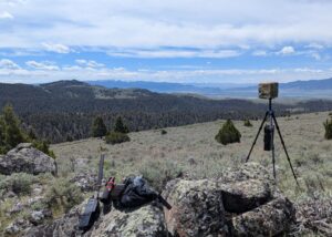 Overview The Tough Stump Rodeo is an outdoor edge technology demonstration set in rural Montana.Selected companies collaborate to integrate their capabilities with the ATAK common-operating-picture to complete communications challenges. CloudRF participated for the first time as a key enabler on the most challenging lane, the sub-terranean, which required participants to… Read more: Tough Stump Rodeo 2026
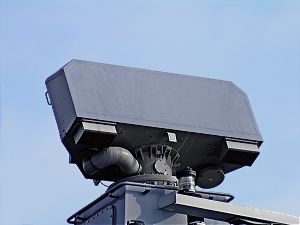 Modelling Radar and Wireless interference in the 5GHz range Background In the early morning of the 4th of July 2025, the Australian warship HMAS Canberra sailed down the west coast of the North Island of New Zealand. It had its navigation radar on, surveying the sea for obstacles. At the… Read more: How a passing Warship took out a town’s Internet
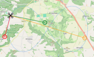 The rapid growth of Counter Unmanned Aerial Systems (C-UAS) across government, public, and commercial sectors has increased the need for accurate modelling to improve sensor siting and effectiveness. This blog explores how Counter- (C-UAS) and RADAR systems can be modelled efficiently within CloudRF to optimise siting and improve their effectiveness. The challenge The methodology for operating sensors varies depending on… Read more: Optimising drone detection with RF simulation
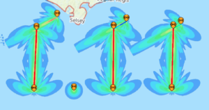 The first feature release of 2026 brings new MANET APIs with receiver antenna patterns, a major container refactor, offline 3D terrain, high accuracy tree canopy data and simpler licensing. Multi link API This API is designed for mesh and MANET networks and has already replaced the points API for the… Read more: SOOTHSAYER 1.11 released
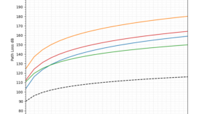 Author: Cameron Mickell A common question for novice planners is which RF propagation model is best for my technology? We have many different users employing diverse technologies, time constraints and accuracy requirements, so it is not always a quick answer but knowing about the key types of models and where… Read more: Choosing an RF Propagation Model
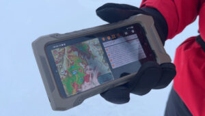 Summary We conducted a field test in the mountains with SOOTHSAYER focused on automation and endurance. The test generated quality data and revealed altitude issues with our plugin we have since fixed. We conducted a field test in the mountains with SOOTHSAYER focused on automation and endurance. The test generated… Read more: Live network mapping endurance test
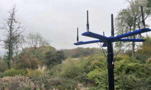 Background Radio Direction Finding (DF) is the art of determining the location of an emitter and is used in search and rescue, coastal surveillance, law enforcement and defence. There are different techniques using power and phase but the output for a single sensor is normally a Line of Bearing (LoB)… Read more: Enhancing Radio Direction Finding with RF simulation
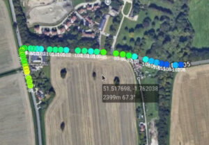 To Survey or Simulate Whether its survey drones, drive test vehicles or a police analyst with a backpack full of phones, the problem is the same: RF propagation surveys are very resource intensive. They’re more accurate than a simulation, but not more efficient. Survey data is typically a GPS log… Read more: Fast simulation calibration with Machine Learning
 Our latest feature release for our self-hosted server is out now and majors on offline data and security hardening. It’s a release aimed at administrators with six months of CloudRF fixes and features including the noise layer. Offline data packs Since we released pre-built images with 1.9, the setup effort… Read more: SOOTHSAYER 1.10 released
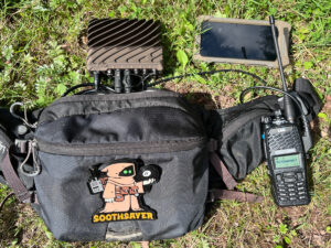 Highlights Background Three years ago we developed a “live” simulation capability using location-aware MANET radios which we described as dynamic radio planning which fused real and planned radio positions. This feature required a third party hardware API with restrictive terms, common in commercial radio, so it exists as a video… Read more: Live RF coverage mapping with ATAK
 Summary We have optimised how our engines model attenuation and diffraction to improve accuracy and performance within forests (and buildings). Highlights Evolution of attenuation and/or diffraction When a radio signal hits an obstacle such as a building, it attenuates through the obstacle and diffracts over the obstacle. Depending on the… Read more: Improving accuracy in the trees
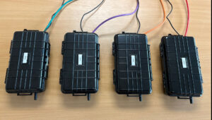 Noise is the single biggest factor in determining the quality of a communications link. It’s also the reason why there is low confidence in the accuracy of (RF) simulation in complex environments as it’s rarely done well, if at all. Budgeting for noise is critical to achieve desired signal levels.… Read more: Mapping Noise
 We’ve published a series of video tutorials for HF novices to bring to life HF theory around the topics of Frequency selection, Antenna fundamentals and forecasting. HF communications is very different to terrestrial communications and given the right frequency, time of day, and antenna, you can achieve long range links… Read more: The art of HF
 Our latest feature release improves offline setup and adds support for HF Skywave, interference analysis and indoor simulation. Offline by default With pre-built images, offline install is now enabled by default. This was developed to both speed up the install, ensure all dependencies are present and correct and automatically assign… Read more: SOOTHSAYER™ 1.9 released
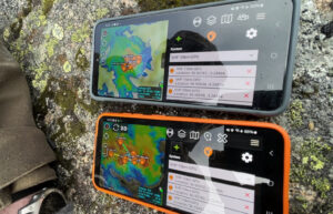 Developments in containerised software and portable GPU hardware have enabled RF simulation at the network edge. Field testing has proven this powerful capability can serve multiple clients from a small battery for a sustained period of time. Key findings Test setup An Nvidia Jetson Orin nano 8GB processor was paired… Read more: RF planning at the Edge
 Simulating indoor radio coverage for first responders has been made simpler thanks to a new capability called Phase Tracing. The novel design was influenced by the 2017 Grenfell Tower inferno, where radio communication in concrete stairwells was highlighted as a major problem. The Grenfell inquiry highlighted radio and training issues… Read more: Phase Tracing interface
 Interference is one of the single biggest issues in radio which limits the potential of a system or network. There are different types of interference but the problem of interference visualisation is common to all. With simulation software you can model your system, and an interfering system, but understanding the… Read more: Interference analysis
 HF Ionospheric propagation, known as Skywave, has been added to the CloudRF API. While Satcom offers clear advantages in terms of speed, bandwidth, and the ability to provide real-time, high-quality data transmission, HF remains a crucial alternative where cost, independence from satellites, portability, power efficiency, and resiliency are important. Wide… Read more: HF Skywave
 Our latest feature release adds new APIs and retires the virtual machine for a container-first solution compatible with more host systems which enables GPU sharing and greater control over both code and user data. 3D API A new full 3D API and GPU engine designed for urban simulations with multipath,… Read more: SOOTHSAYER 1.8 released