The latest release of our private server, SOOTHSAYERTM is now available with bigger limits, better reference data, VSphere 8 enterprise GPU support, enhanced security controls and improved performance.
GPU clutter attenuation
The GPU engine can now model clutter attenuation in the same way as the CPU engine, only much faster. This functionality works for our global land cover for forests, global buildings data, and even custom clutter for BYO obstacles. Clutter profiles for regions and seasons are configured through the interface as normal.
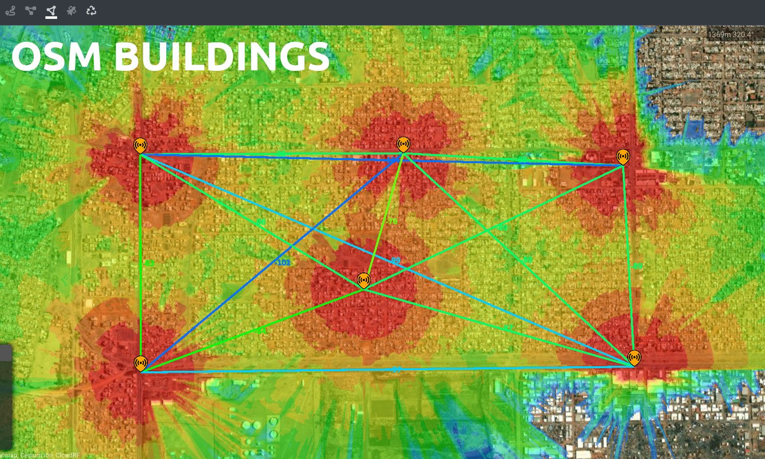
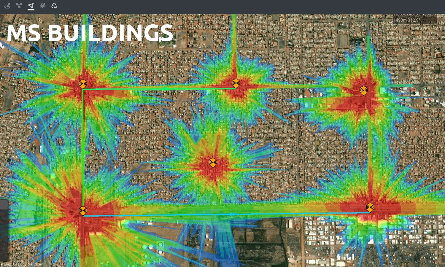
Global buildings
We have replaced OpenStreetMap buildings with Microsoft buildings, generated from machine learning trained on satellite imagery. This provides much better data for planning in rural areas and countries which traditionally have suffered from poor data coverage. In the comparison below in Khartoum, Sudan, MS buildings produce a much more conservative result owing to their comprehensive coverage with OSM’s crowd-sourced data lacks.
A SOOTHSAYER server now has global buildings which can be side loaded by country into the data folder or fetched on-demand via api.cloudrf.com when connected to the internet.
Antennas and utilities
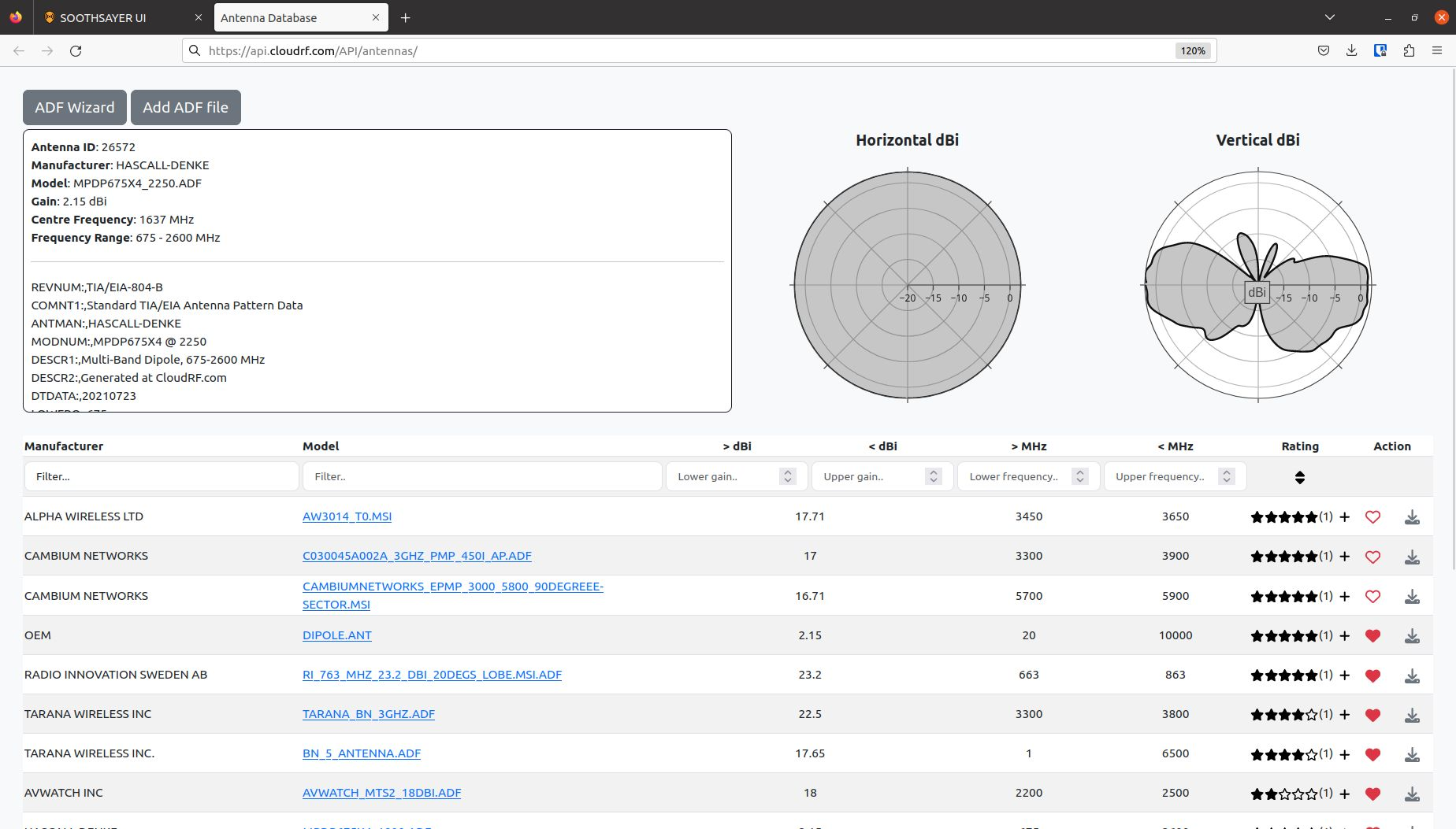
Previously SOOTHSAYER’s antenna database was sparse but now it ships with over 500 patterns from major OEMs as well as improved tools to validate, convert different text formats, import ADF patterns and search. Pattern images have been retired for dynamic plots direct-from-source so what you see is what you get and the custom plots are indistinguishable from OEM patterns in both the UI and outputs.
The new look database lets you find patterns quicker than ever with responsive filters. Type the first few letters of what you’re looking for to reduce search results.
The rating feature lets your team score patterns so “the good ones” are always top of the list.
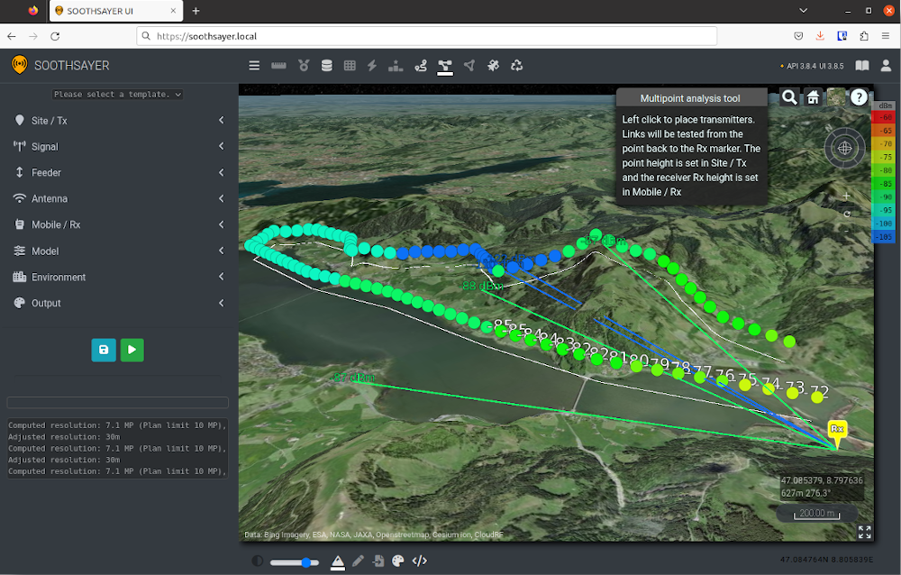
Enhanced MANET limits
Limits for the Multisite API and it’s flasgship MANET tool have been enhanced. You can now do 500km radius / 310 Mile MANET sites and networks that are 2000km wide.
If you try to create a network across the Atlantic Ocean this won’t work….yet.
VSphere 8 support
SOOTHSAYER has been successfully tested on enterprise servers (HPE) with VSphere 8 and a Nvidia T4 GPU. VSphere 8 uses UEFI firmware (instead of BIOS) by default which is becoming the norm as enterprise moves towards trusted platform architectures.
It has also been tested with Proxmox, Virtualbox and Azure environments. We recommend Proxmox for SOOTHSAYER for the widest GPU support (RTX etc) and VSphere for enterprise GPUs.
You can install the VM on a GPU laptop with Linux but this is only recommended for people who like a challenge. We have a tutorial video and instructions available for this.
ATAK plugin
It comes with a free TPC signed plugin for ATAK 4.8: https://github.com/Cloud-RF/SOOTHSAYER-ATAK-plugin
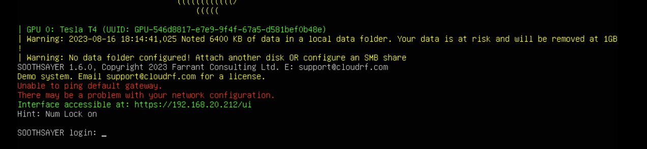
Simple data storage with a second drive
You don’t need to mount an SMB share for your data anymore! (You can if you want to though…)
Just attach a second disk to the VM and reboot. You decide the size. Your terrain data and user files will be saved to this disk. The database remains encrypted inside the first disk.
If you don’t then you can still use it but will get warnings telling you about disk limits it in the CLI:
Change log
1.6.0
API v3.8.10
3.8.10 (2023-08-16)
- Improvement: New default dBm and dB colour keys
- Improvement: Enhanced admin dashboard for server
- Improvement: Auto-rotate function for misaligned patterns refined
- Fix: A private server will fetch MS buildings from CloudRF before OSM
- Fix: Path and route ATAK data packages not working in ATAK.
- Fix: Downloading
.antreturnsNANandINF. - Fix: GPU elevation pattern downtilt aligns with CPU
3.8.9 (2023-08-05)
- Improvement: More verbose errors for engine/data failure
- Improvement: Handling and logging corrupt DTM files
3.8.8 (2023-07-31)
- Improvement: MANET KMZ now returns points and heatmap
- Fix: Refactored antenna pattern parsing
- Fix: Fixed bug in antenna auto-alignment
- Fix: Sorting MANET files to use latest when requesting KMZ
3.8.7 (2023-07-25)
- Improvement: MANET networks in the archive show average value for each of the columns.
- Improvement: Added support for MS 2m buildings via buildings option
- Improvement: Using buildings will now only go to OSM as a last resort
- Improvement: System clutter profiles adjusted to make vegetation more dense
- Fix: Remote tile download not working with DTM tiles.
3.8.6 (2023-07-21)
- Improvement: Custom antenna optimisations
- Feature: Redesign of antennas database to make use of ADF files.
- Fix: Handling legacy .ANT patterns not referenced to 0dB PEP
3.8.5 (2023-07-05)
- Improvement: GPU can now do 500km radius with a minimum 180m resolution
- Improvement: Multisite limit increased to 2000km for wide networks
- Improvement: Logarithmic custom antenna pattern radiation
3.8.4 (2023-06-23)
- Improvement: GPU calcs can now use custom clutter
- Fix: Storing antenna gain before feeder loss adjustment
- Fix:
areaandcoveragevalues returned in KMZ balloon not being calculated. - Fix: When using PPA tool network name is appended with
_PPAto separate from other calculations in the archive. - Fix: Interference tool not working with GPU calculations.
3.8.3 (2023-04-24)
- Feature: Added
sessionendpoint to get current load state of API in the response of a PNG image. - Feature: Area calculation
siteandnetworkparameters now accept Latin letters which are not in the ISO basic Latin alphabet. - Feature: Added
remaining_calculations_since_last_purchasetomy-metricsAPI. - Feature: Added
edgesargument to a BSA request to allow an area to be defined for a BSA area which is cut out during processing. - Feature: Requesting
tifffile type on anarearequest returns both3857and4326projections. - Improvement: Requesting
tifffile type via the archive is now compressed to reduce size and transfer time. - Improvement: Additional error reporting and logging.
- Fix: Antenna search form now shows all patterns for a given OEM when name is selected even if search string not present in description/filename
- Fix:
siteis not a required field. - Fix: Google Earth throws an error upon first loading a coverage layer in relation to the PPA tool. This was causing errors as the PPA tool is called immediately after the loading of the coverage layer of which both the transmitter and receiver locations were the same.
- Fix: Some temporary files not being removed during cleanup process.
- Fix: User clutter files being copied to wrong location when using GPU processing engine.
- Fix: Google Earth throws an error upon first loading a coverage layer in relation to the PPA tool. This was causing errors as the PPA tool is called immediately after the loading of the coverage layer of which both the transmitter and receiver locations were the same.
- Fix: User clutter files being copied to wrong location when using GPU processing engine.
- Fix: Submitting
receiver.latorreceiver.lontoareaendpoint causes calculation failures. - Fix: Timings no longer output for error messages on production.
- Fix:
creditsreturned frompreferencesnot factoring in requested calculations. - Fix: Loading KMZ into Google Earth would immediately fire off a PPA calculation.
- Fix: Calculations made in Google Earth would always have
TESTnetwork name.
3.8.2 (2023-03-28)
- Improvement: Polarity for custom patterns
- Fix: Rx gain NULL after using interference tool
- Fix: All KMZs contained the GE ppa tool
- Fix: Removing gain from ADF patterns so all are referenced to 0dB PEP
- Fix: Using Signal to Noise units with a receiver sensitivity of 0 dB caused an issue
- Fix: Google Earth PPA tool could fail when both markers were stacked up. Now fails gracefully.
- Fix: Antenna model and OEM search filters was using OR vs AND
3.8.1 (2023-03-02)
- Improvement: GPU engine has improved Huygens diffraction
- Improvement: Colour steps can now be any value between -30 and +30
- Improvement: New buildings are now fetched synchonously so will block for request #1 up to a max of 30s
- Improvement: Extended bandwidth lower limit from 10kHz (0.01MHz) to 1kHz (0.001MHz).
- Improvement: Extended noise floor lower limit from -140 to -150 dBm.
- Improvement: Requesting a network which doesn’t exist in a
meshcalculation will indicate up to 3 network names which have been used recently. - Improvement: Chatbot authentication process simplified. The user ID will always be the ID of the Chatbot.
- Improvement: Extended bandwidth lower limit from 10kHz (0.01MHz) to 1kHz (0.001MHz).
- Improvement: Extended noise floor lower limit from -140 to -150 dBm.
- Commercial: Ibiza is no longer the anonymous-full-spectrum-party-island due to abuse. A plan is required to test.
- Fix: Tightened restrictions on users on free plan.
- Fix: Interference tool failing to produce result.
- Fix: Bug in SLEIPNIR JSON report for very low power levels eg. 0dBm with feeder loss. Fixed as 1.6.2
- Fix: Points megapixel calculation ignores radius in favour of point distance. Hard limit of 64MP
- Fix: Confusing error messages when running a
meshcalculation. - Fix: Chatbot outputs any returned error messages when a multisite API request fails.
- Fix: Tightened restrictions on users on free plan.
- Fix: Interference tool failing to produce result.
- Fix: Show the callsign of the device which is authenticated with Chatbot as this is more useful than a device ID.
- Fix: Requesting 3857 projections for GPU calculations (viewshed, BSA, multsite) returning HTTP 404.
- Fix: Selecting a bad antenna ID would throw a HTTP 500 with no output error message.
- Fix: PPA URL outputs will return a secure encrypted URL so as to now expose information via the public URL.
- Fix: Multisite endpoint reporting validation errors for some imperial units.
- Fix: Multisite endpoint not honouring imperial units.
UI v3.8.8
3.8.8 (2023-08-15)
- Update: Satellite database updated to 01/08/2023.
- Fix: Calculate ERP after switching antenna pattern
- Fix: BSA colour key no longer disabled when BSA fails
3.8.7 (2023-07-31)
- Feature: Added a download KMZ button to the MANET tool.
- Fix: Skips polygons and polylines with no coordinates when uploading KML as clutter.
- Fix: Bit error rate and modulation drop downs missing in Google Earth.
- Fix: GPU engine enabled no longer hides the play button to allow calculations to be made without changing settings.
- Fix: Gracefully fail with a message when unable to load path profile results from the archive.
- Fix: Gracefully fail with a message when an image could be loaded properly for some scenarios.
- Fix: Multi-point results hover in the sky when turning off 3D terrain.
3.8.6 (2023-07-13)
- Fix: Buildings on the Path Profile Chart were all being bunched up on the left when land cover was turned OFF.
- Feature: “My patterns” antennas makes use of recent updates to API endpoints and draws pattern plots rather than outputting JPEG images.
- Fix: Antenna menu labels tidied and widths standardised. Horizontal is now H, Vertical is now V.
3.8.5 (2023-06-23)
- Fix: Handling blocked sentry script with link to adblocker FAQ
- Fix: Metric/Imperial logic in Multisite tool
- Fix: MANET links not showing if no preference set
- Fix: ERP not recalculated when reloading from archive
- Fix: Deleted archive images now throw a error
3.8.4 (2023-05-23)
- Enhancement: Loading page with async loader for large JS assets
- Enhancement: Added “Hide Node” functionality to the MANET context menu.
- Enhancement: Sets the default antenna gain when selecting an antenna.
3.8.3 (2023-04-24)
- Fix: Removed “Plane Earth Loss” from models list.
- Fix: Using “Line of Sight” model automatically sets diffraction to “Off”.
- Fix: Improved error handling and reporting.
- Fix: Issue when changing the colour schema while best site analysis is processing a drawn polygon.
- Feature: API load status light added in top navbar upon page load.
- Fix: Marker pin on MANET nodes at top of plumbline rather than at ground level.
3.8.2 (2023-03-28)
- Enhancement: Welcome screen while loading ui.
- Enhancement: Added reference data import dialog for CSV,KML,GeoJSON.
- Enhancement: Increased 1000 row limit for CSV to 60k (Make sure your device has lots of memory if you use this)
- Enhancement: BSA KML polygons via reference data form
- Enhancement: MANET KML locations via reference data form
- Enhancement: KML reference points via reference data form
- Fix: Issue when entering invalid DMS coordinates.
3.8.1 (2023-03-03)
- Improvement: Upgraded CesiumJS to the latest version.
- Fix: Mouse hover tooltip value lookup to use the correct schema for multiple layers with different schemas.
- Fix: Error messages from API for MANET tool not being output.
- Fix: MANET failed links are styled which is confusing, particular when zoomed out and dashed line is not visible.
- Fix: Best server tool able to misfire on GPU area calculation upon click.
- Fix: Allow for imperial units with MANET heatmap which adds locking to the
disvalue to prevent unit mismatch.
More information
To request more details see here, or to get a quote or a demo VM, get in touch from your official email.
