CloudRF is the service for modelling radio propagation.
There’s nothing to install but you get premium features you’d expect from a legacy desktop package. Pay for a plan and you are ready to go in your browser. No more downloading gigabytes of terrain data, antenna patterns or preparing clutter layers – we have it all installed and ready to go and add more regularly by request. You don’t need to attend long and expensive training – if you’re not sure about something help is only a click away.

Designed for operators, by operators
The intuitive interfaces have been built and shaped from user feedback since its inception as an Android app in 2011. It covers the entire above-HF RF spectrum with generous height ceilings and distances for aircraft, large power limits for long range broadcasters, meshes for WISP and IoT networks, cellular propagation models for mobile networks and environmental variables to accommodate suburban, rural and mountain planners alike.
The empirical and deterministic models available are applicable for most wireless technologies and the cross-platform interfaces are simple enough for novices with advanced features for professional engineers including bit error rate.
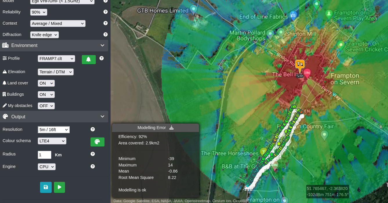
Our SLEIPNIRTM CPU propagation engine was purpose designed for high performance and compatibility with modern clutter data sets and our economical GPU engine can model millions of LiDAR points at 1m resolution in milliseconds – without kilowatts of power.
Our mission
We want to make radio planning accessible. We’re achieving this not through cost alone as there’s mature free solutions out there but accessibility. This starts with our clear and reasonable pricing which we’re not embarrassed to publish. Radio modelling is complicated and normally needs an enormous amount of resources and preparation to do it accurately. We want it to be accurate, affordable and user-friendly.
We want to develop a mature, stable and accessible service which you can help with by giving feedback.
Who we are
The business is a bootstrapped micro SME, based in Gloucester in the United Kingdom with a presence in the UK, Europe and US. We’ve been going 10 years and are used worldwide in every radio industry imaginable. Our customers include market leading tech firms, NGOs, the UN, GSMA, Governments, spectrum authorities, universities and radio manufacturers. We’re the tool used in high profile events, disaster relief and anywhere radio features.
It was founded by Alex Farrant CEng who has worked in radio for over 22 years. He mastered the art of radio propagation throughout an active military career in telecommunications in austere environments. Whilst serving in 2011, Alex developed a popular Android app for pocket RF planning which evolved into CloudRF.
The CloudRF team is small but mighty and we enjoy punching above our weight!

Innovation timeline
At CloudRF we pride ourselves in innovation and have transformed the way people conduct radio coverage modelling, disrupting what was a very expensive and exclusive, windows desktop market. Prior to CloudRF it was not unusual for companies to spend $10k to $80k(!) a year on a license for desktop radio software. Those same companies are now getting access for multiple employees, from any device, for a fraction of that amount which aside from cost, puts planning tools into the hands of staff across a company, not just Bob.
- 2011 – RFSignal for Android launched, reached top 50 in communications category on Play
- 2012 – CloudRF.com website launched with web interface and global 90m DEM (Origin 2000)
- 2013 – Keyhole Radio™ interactive layer for Google earth
- 2014 – Lots of features added to engine and interfaces, Virtual machines offered
- 2015 – More propagation models, channel intersection and mesh features
- 2016 – LiDAR high resolution support in engine and interfaces. UK 2m and US city DSM uploaded
- 2017 – Drone photogrammetry support via Pix4D, more servers, global DSM at 30m (Origin 2014)
- 2018 – New LiDAR propagation engine SLEIPNIR developed. LIDAR for NZ, Estonia, Sweden, DC, Baltimore..
- 2019 – Seamless 30m Landcover with 584 types for CONUS and EU, KML ‘do-it-yourself’ clutter upload, 3D clutter with material densities
- 2020 – 3D buildings with configurable attenuation, 3D cross-platform interface
- 2021 – ATAK support. SOOTHSAYERTM Virtual machine with BYO LiDAR launched, 10m global clutter
- 2022 – GPU engine, Satellite planning tool, MANET planning tool, Best Site Analysis (GPU)
- 2023 – Multisite (GPU) for modelling the entire network in one API call.
Follow CloudRF updates on Twitter.
Supported technologies
Anything that uses radio from 20-90,000MHz. We bound ourselves by the laws of physics not regulatory bodies or manufacturers. The tool can be used to support specific standards like LTE / 4G / 5G but won’t have advanced protocol specific parameters. It will however show you the path loss for an eNodeB at 15m above ground level on 800MHz with LiDAR accuracy.
Platforms
Android, Linux, Mac/OSX and Windows are all supported. Our 3D interfaces adjust to any device from an iPad to desktop computers. Google Chrome is recommended for best performance.
Free software is only free if you don’t value your time
We built CloudRF as an easy interface to complex command line modelling software as we knew lots of people, especially small businesses, needed RF planning tools but couldn’t justify $10,000-80,000 for a premium Windows software package or have the advanced RF or Linux expertise required to effectively use Radio Mobile or SPLAT! (We no longer use SPLAT!)

We’ve been perfecting our software-as-a-service over 10 years to make it fast, easy and accurate. We’ve watched many customers and competitors, big and small, try to do the same and quit as either they’re out of time, or in the case of development teams they’ve spent more than the cost of a premium package – and still haven’t got an MVP. There is no one secret formula we have (we have lots :p) except we’ve spent over 10 years mastering complex terrain data, clutter data, antenna patterns, interfaces, engines, HPC, propagation models, diffraction, attenuation, GIS, LiDAR, web services and APIs.
EXPENSIVE WARNING
We’ve had the biggest names in tech try and copy what we do in the +10 years we’ve been doing it and all have failed to different extents: Some failed quietly and the team moved on. Some spent an enormous amount to produce slower, simpler, replicas using old open source engines which they can’t give away. One household name disguised themselves as a communications charity to leech IP and they still failed to compete.
This is more complex than it looks on the face of it and our service will save you a fortune, so you can focus on your system. If you’re concerned about liability and SLAs etc – talk to us about a contract and/or a server. Integrating third party software into another system is a solved problem.
Pricing
We set the bar for pricing of SaaS RF modelling software. Our low pricing reflects our open source roots and is designed for small businesses, students and consultants. Sales teams from 1990s companies selling Windows tools say our software is inaccurate (but never slow :p) but customers who have come from there and stayed with us for years disagree. If you have a link you want us to compare to prove it just email support@cloudrf.com
We’re not perfect: One of our propagation models dates back to 1946 but because no-one updated the laws of physics it delivers for urban IoT today…
Certification