Cloud-RFTM is a user friendly service for modelling radio propagation
There’s
nothing to install but you get premium features you’d expect from a legacy desktop package. Pay for a plan and you are ready to go in seconds. No more downloading gigabytes of terrain data, antenna patterns or preparing clutter layers –
we have it all installed and ready to go and add more regularly by request. You don’t need to attend long and expensive training – if you’re not sure about something help is only a click away.
The intuitive interfaces have been built and shaped from 20 years of radio experience and 8 years of user feedback from its inception as an Android app in 2012. It covers the entire above-HF RF spectrum with generous height ceilings and distances for aircraft, large power limits for long range broadcasters, meshes for WISP and IoT networks, cellular propagation models for mobile networks and environmental variables to accommodate suburban, rural and mountain planners alike.
The empirical and deterministic models available are applicable for most wireless technologies and the cross-platform interfaces are simple enough for novices with advanced features for professional engineers including bit error rate.
Our
n-threaded SLEIPNIR
TM propagation engine has been designed for use with precision LiDAR surface models and 3D buildings and is up to ten times faster than open source engines.
Our mission
We want to make radio planning
easy and
accessible. We’re achieving this not through cost alone as there’s established free solutions out there but
simplicity. This starts with our clear pricing which we’re proud to publish.
Radio modelling is complicated and normally needs an enormous amount of resources and preparation to do it accurately. We want it to be simple, affordable, fast and user-friendly.
We want to develop a mature, stable and
user friendly service which you can help with by
feedback.
Who we are
The business Cloud-RF
TM is an independent UK company, based in South West England with servers in Germany.
It was founded by
Alex Farrant who has worked in radio for over 20 years and software development for 8. He mastered the art of radio propagation throughout an active military career specialising in telecommunications, antennas and propagation. The idea was realised when (very) expensive military-grade solutions were not being used because they were too complicated and the software was available to only 1 person – who was very busy. Alex ran a backdoor service on operations for KML RF overlays, produced by the open source SPLAT! utility which proved popular. In between deployments he created the first ever
Android app for pocket RF planning.
As well as CloudRF, he consults in wireless security research and has published relevant articles on
Drone detection,
Wireless congestion and presents occasionally including
GPS spoofing at London shipping week. His RSGB callsign is 2E0TDW and one day he might actually have time to use it..
Developers
The software development at CloudRF is performed by contractors. Our blazing fast engine Sleipnir is the work of Gareth Evans, a senior C++ developer with over 20 years experience who specialises in optimised code for multi-core intel processors.
Our proprietary LIDAR processing capabilities have been developed by GIS specialists for maximum accuracy and compatibility with standards and tool chains.
We’re always on the lookout for experienced developers or GIS specialists with an interest in radio and normally have a backlog of ideas if you’re looking for a project.
Innovation timeline
At CloudRF we pride ourselves in innovation and have transformed the way people conduct radio coverage modelling, disrupting what was a very expensive desktop market. Prior to CloudRF it was not unusual for companies to spend £10k on a single license for desktop radio software. Those same companies are now getting access for multiple employees for a fraction of that amount which aside from cost, puts planning tools into the hands of staff across a company, not just one or two Engineers.
- 2011 – RFSignal for Android launched, reached top 50 in communications category on Play
- 2012 – CloudRF.com website launched with web interface and global 90m DEM (Origin 2000)
- 2013 – Keyhole Radio™ interactive layer for Google earth
- 2014 – Lots of features added to engine and interfaces, Virtual machines offered
- 2015 – More propagation models, channel intersection and mesh features
- 2016 – LIDAR high resolution support in engine and interfaces. UK 2m and US city DSM uploaded
- 2017 – Drone photogrammetry support via Pix4D, more servers, global DSM at 30m (Origin 2014)
- 2018 – New LIDAR propagation engine SLEIPNIR developed. LIDAR for NZ, Estonia, Sweden, DC, Baltimore..
- 2019 – Seamless 30m Landcover with 584 types for CONUS and EU, KML ‘do-it-yourself’ clutter upload, 3D clutter with material densities
Follow CloudRF updates on
Twitter.
Where we are
The business is based in Gloucester, England with regional servers in Canada, the UK and Germany.
Customer data is stored and processed securely in accordance with EU GDPR regulations and CloudRF.com is PCI certified by Trustwave Inc to handle credit card information.
Supported technologies
Anything that uses radio from 20-100,000MHz. We bound ourselves by the laws of physics not regulatory bodies or manufacturers. The tool can be used to support specific standards like LTE / 4G but won’t have advanced protocol specific parameters. It will however show you the path loss for an eNodeB at 15m above ground level on 800MHz with sub 30m accuracy.
The following, non-exhaustive list of standards, are supported: Marine VHF, Air band AM, PMR, DMR, VHF/UHF PTT, LoRa, GSM, UMTS, LTE, 5G, Wi-Fi, Wi-Max, Wi-Gig.
Platforms
Android, Linux, Mac/OSX and Windows are all supported. Our unique Google earth plugin ‘Keyhole Radio™’ lets you run the software directly from within the application.
CloudRF for radio theory training
Using an interactive tool
allows novice students to learn radio theory quicker, in a representative scenario, rather than death-by-powerpoint. With over 50 years of operational radio experience on the team covering all aspects of tactical communications we have developed tools popular with students and are well qualified to deliver RF theory training with the CloudRF platform.
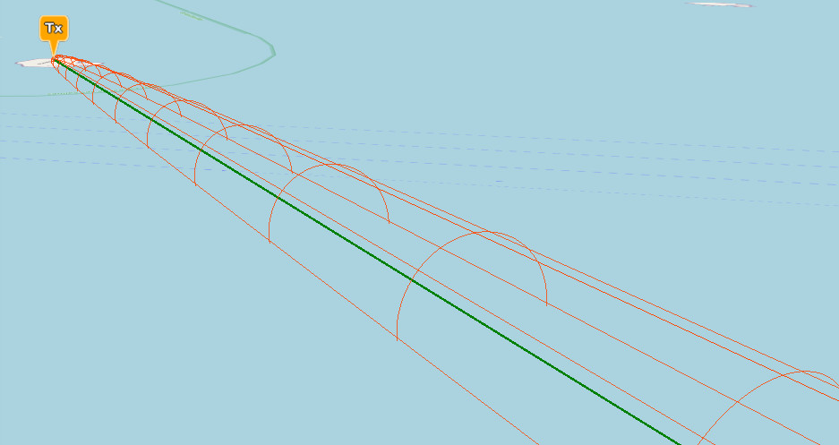
The 3D visual aspects of CloudRF allow complex Radio Engineering topics such as the relationship between wavelength and the Fresnel zone to be effortless demonstrated.
For training information and pre-priced packages, please see our
training page.
Machine learning and AI?
We understand the many challenges in accurate simulation enough to know that
there are no shortcuts. We’ve been perfecting our terrain data, clutter, antennas, models, diffraction and noise to achieve the best accuracy we can. This requires serious
field testing and years of R&D to produce a consistent, accurate and scalable API.
When our API is used by a system which employs Machine Learning it provides a cost efficient way to generate and analyse the data for radios, drones and systems at scale. We are the basis for Machine Learning and analytics and have the API which can provide answers Machine Learning cannot without empirical measurements.