


Terrain Data
The system works with raster data in either ASCII grid or GeoTIFF formats.
VM users can add their own tiles by placing them in the mapped /data/DSM/ folder and clicking “Reprocess DSM” within the admin dashboard.
GeoTIFF tiles need to be of type Int16 in WGS84 (EPSG:4326) projection with a pixel resolution of between 1 and 30m.
For a map of system data see Terrain data map.
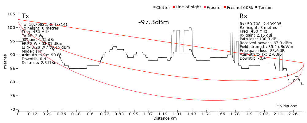
When using LiDAR data, users should be aware that it is a single surface layer which includes buildings. Therefore if you have a 2m mast on top of a 20m building this is still a height of 2m for the input form. If you do not have LiDAR but do have a digital terrain model (DTM), you would need to enter a height of 22m to simulate a 2m mast atop a 20m building.
Global DSM
The CloudRF data baseline is an ALOS30 30m digital surface model from the Japanese Space Agency (JAXA).
The ALOS Global Digital Surface Model (AW3D30) is a global dataset generated from images collected using the Panchromatic Remote-sensing Instrument for Stereo Mapping (PRISM) aboard the Advanced Land Observing Satellite (ALOS) from 2006 to 2011. As described by the Japan Aerospace Exploration Agency: The Japan Aerospace Exploration Agency (JAXA) releases the global digital surface model (DSM) dataset with a horizontal resolution of approx. 30-meter mesh (1 arcsec) free of charge. The dataset has been compiled with images acquired by the Advanced Land Observing Satellite “DAICHI” (ALOS). The dataset is published based on the DSM dataset (5-meter mesh version) of the “World 3D Topographic Data”, which is the most precise global-scale elevation data at this time, and its elevation precision is also at a world-leading level as a 30-meter mesh version. This dataset is expected to be useful for scientific research, education, as well as the private service sector that uses geospatial information.
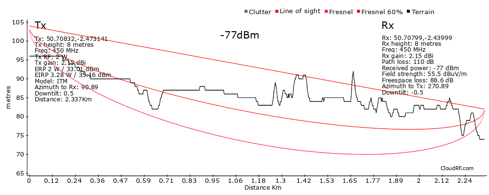
LiDAR
The ALOS30 data is supplemented in some countries (eg. UK,Estonia) and cities (eg. Auckland, Brisbane, SF, NYC, DC, Mogadishu, Tashkent, Nova Scotia) by high resolution LiDAR at 2m accuracy from various sources, typically national environment agencies like Kartvekat in Norway or the UK Environment Agency. Care is taken to ensure the data is reprojected correctly to EPSG 4326.
Clutter
Clutter items are placed on top of the surface model. When using high resolution LiDAR this can result in abnormally high obstacles if your clutter items are tall. Under this scenario, use a clutter profile with short obstacles eg. 1m. This will simulate the appropriate clutter without the excess height. For more on clutter see the clutter section.
 {title=”LiDAR path profile” style=”width:800px”}
 {title=”DSM and clutter path profile” style=”width:800px”}